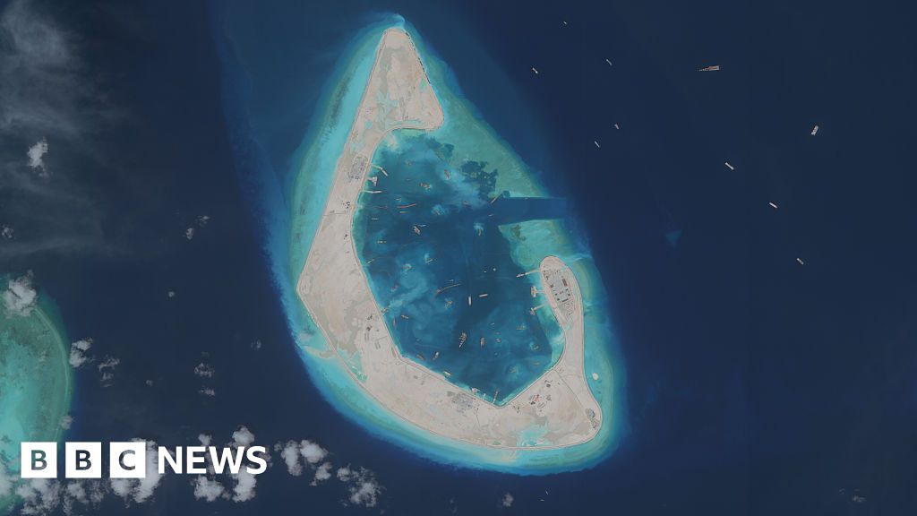
Chinese authorities confirmed the completion of a military-grade installation on Antelope Reef this week, marking one of the fastest territorial expansions in the contested South China Sea. The reef, previously submerged at high tide, now hosts a 40-acre artificial island equipped with radar domes, missile silos, and a runway capable of handling fighter jets. Satellite imagery analyzed by independent defense analysts shows construction began in March 2024 and was completed in under 18 months—a pace unmatched in the region’s maritime disputes.
Defense officials in Manila and Washington confirmed the development aligns with Beijing’s broader strategy to solidify control over the South China Sea. The reef sits within the Philippines’ 200-nautical-mile exclusive economic zone, a claim Beijing disputes under its controversial nine-dash line map. Filipino fishermen reported increased Chinese coast guard patrols near the area last month, with reports of vessels blocking access to traditional fishing grounds.
| Claimant State | Territorial Claim | Recent Action |
|---|---|---|
| China | Nine-dash line covering ~90% of the South China Sea | Completed military installation on Antelope Reef |
| Philippines | 200-nautical-mile EEZ around its archipelago | Filed diplomatic protests |
| Vietnam | Historical sovereignty over Spratly Islands | Condemned "illegal construction" |
| Malaysia | UNCLOS-defined continental shelf rights | Monitoring developments |
The U.S. State Department called the construction a "direct threat to regional stability" and announced plans to conduct a "freedom of navigation" operation near the reef within 30 days. China’s Foreign Ministry dismissed the criticism as "irresponsible provocation," reiterating that the installations are for "peaceful purposes."
Key Points
- ✅ China completes 40-acre military installation on Antelope Reef in 18 months
- ⚡ Reef sits within Philippines’ exclusive economic zone, disputed by Beijing’s nine-dash line
- 💡 U.S. to deploy freedom of navigation operation near the reef within 30 days
Local fishermen in Palawan, Philippines, described the sudden militarization as a "noose tightening around their livelihoods." One captain recounted being turned away by Chinese coast guard vessels while attempting to reach traditional fishing grounds near the reef, a route his family has used for generations. The Philippine Coast Guard reported 12 incidents of Chinese vessels blocking Filipino fishermen since June 2025, compared to just three in all of 2024.
💡 Pro Tip
Maritime analysts recommend vessels operating near Antelope Reef to carry transponders and maintain constant communication with coastal authorities due to increased Chinese patrols.
The United Nations Convention on the Law of the Sea (UNCLOS) prohibits artificial islands from generating maritime zones, but China has ignored this provision by claiming the reef generates a 12-nautical-mile territorial sea. Legal experts warn this sets a dangerous precedent, potentially justifying similar expansions by other claimants. The Philippines has vowed to take the issue to the International Tribunal for the Law of the Sea (ITLOS) within six months if China does not dismantle the installations.
📋 By The Numbers
- 40 acres — Size of the artificial island on Antelope Reef
- 12 — Number of Filipino fishermen blocked by Chinese vessels since June 2025
- 30 days — Timeframe for U.S. freedom of navigation operation
Defense analysts at the Asia Maritime Transparency Initiative warn that the installation could extend China’s radar coverage by up to 200 nautical miles, enabling real-time tracking of aircraft and ships across a critical maritime corridor. The reef’s position also allows China to monitor traffic between the Malacca Strait and the Pacific, a route carrying 40% of global trade. With tensions escalating, regional diplomats are scrambling to prevent a military escalation, but the window for de-escalation is narrowing fast.